
East of Lyon, once you are past the ring road, the city stops and the river takes over again. Between the canal de Miribel to the north and the canal de Jonage to the south, the Rhône has left an island of several thousand hectares, with lakes, waterside woodland, meadows and dirt tracks. This is the Grand Parc Miribel-Jonage, about fifteen kilometres from the centre, and it is the green lung of the whole Lyon area.
In summer it is also the city’s fallback beach. As soon as the heat sets in, the shores of the Lac des Eaux Bleues fill up, bikes stream in along the canal, and the park starts to look like a seaside resort dropped into the Rhône floodplain. Which is fine, as long as you know two or three things before setting off: where you may swim and where you may not, where the protected areas begin, and how to get there without spending an hour hunting for a parking space.
The stops below are geolocated. Click “Show on map” to place a spot, or “Directions” to start the route from where you are.
-
Lac des Eaux Bleues
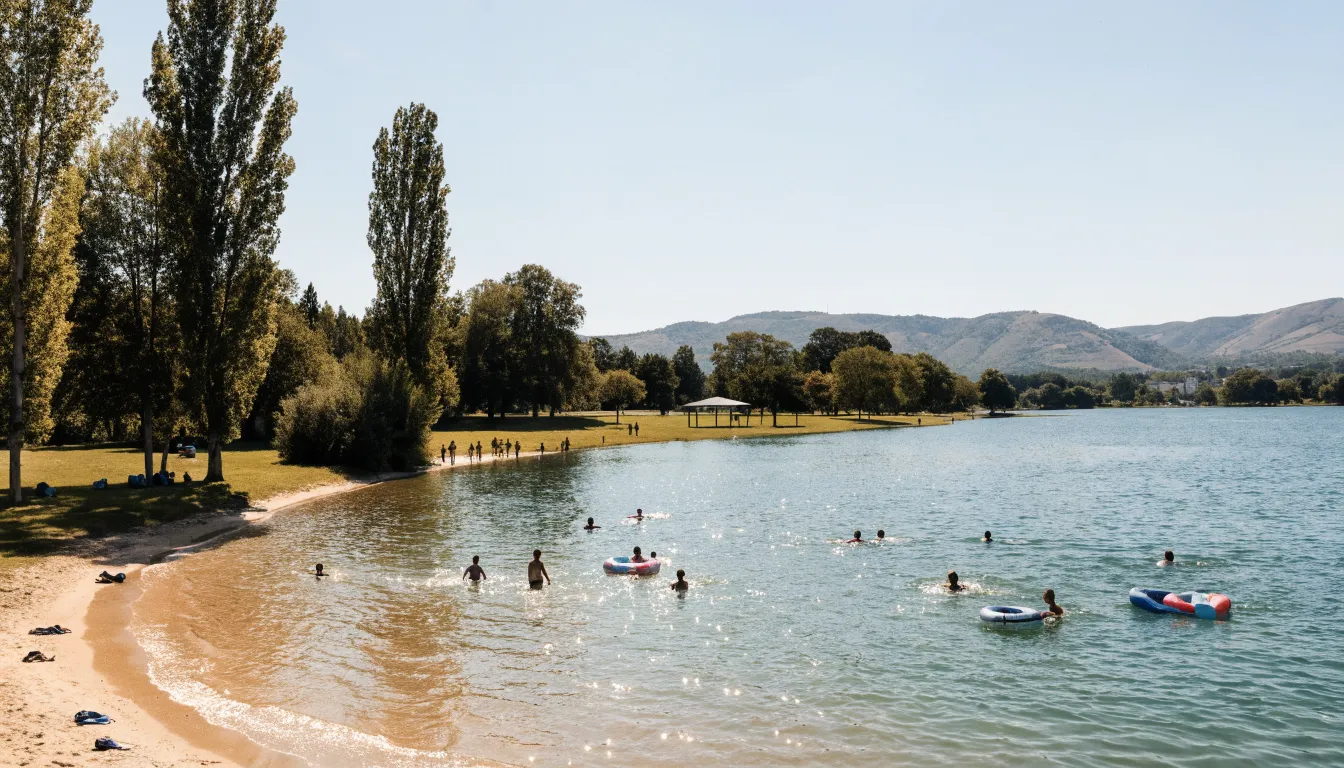
The park's main body of water, left behind by gravel extraction in the Rhône floodplain and fed by the water table. Sandy shores, grass under the poplars, and marked-out swimming areas that draw in a good part of the Lyon area the moment it gets hot.
Swimming is only allowed in the designated, supervised areas. The signs on site and the lifeguards' instructions are what count: the open perimeter and the conditions change from one season to the next.
About 15 km from Lyon, in the order of 25 minutes by road heading east. Without a car, TCL buses serve the park with a metro connection, and it is an easy ride from the city following the canal de Jonage.
-
Grand Parc Miribel-Jonage
Around the lake stretches an estate in the order of two thousand hectares, on the island wedged between the canal de Miribel to the north and the canal de Jonage to the south. Meadows, floodplain woodland, reed beds, dirt tracks: this is the green lung of the Lyon area, and you can walk for hours without seeing a building again.
Part of the site is protected, and a sector to the west is taken up by a well field that supplies the Lyon area with drinking water. Those perimeters are fenced and closed to the public: stay on the open paths.
-
Grand Large sailing centre
To the south, the Grand Large is a widening of the canal de Jonage, between Décines-Charpieu and Meyzieu. This is sailing, rowing and windsurfing territory. People come here to be on the water rather than in it, and from the bank the traffic of sails is worth the detour on its own.
The pin marks the sailing centre area, not a precise address. Here as everywhere on the site, swimming is possible only in the explicitly authorised, supervised zones.
-
Canal de Jonage
Dug in the late nineteenth century to carry Rhône water to the Cusset hydroelectric plant in Villeurbanne, it runs along the southern edge of the park for some twenty kilometres. A path follows it almost without a break from the city: this is the simplest way in by bike, and it is flat from end to end.
The canal is not a swimming spot. The current and the level depend on hydroelectric operations and can change without warning.
-
Jons weir
At the eastern tip of the site, this is the structure that splits the Rhône: part of the flow goes into the canal de Jonage, the rest into the canal de Miribel. The whole landscape of the park follows from that fork. The place is quiet, far from the beaches, with its shingle banks and wooded edges.
The surroundings of a water-control structure deserve respect: do not go down into the river bed, do not cross any barrier, and take the warning signs seriously.
-
Rhône banks at Neyron
At the other end, on the Ain side, Neyron closes the park to the west. Below, flat banks, poplars and tracks; above, the Côtière escarpment rears up at once and looks out over the whole plain. It is the natural way out when you ride back into Lyon along the water.
The pin marks the centre of the commune, not a precise access point to the banks. Lower Neyron is reached from there, across the plain.
1. Lac des Eaux Bleues
This is the park’s main body of water, and the reason half the Lyon area heads out here in July. It is not a natural lake: the Rhône plain was worked for its gravel, and the hollows filled up from the water table. Hence the clear water, the gently shelving shores and the sand that gives the site an improbable seaside feel twenty minutes from Part-Dieu.
Around it, grass under the poplars, tables, and paths that circle the water. The swimming areas are laid out and marked, and this is the one point that matters most in this article: the only safe habit is to swim on the supervised beaches. The signs on site and the lifeguards’ instructions are what count, always. The open perimeter, the days and the supervision arrangements change from one season to the next, and a bathing area can be closed overnight for health or weather reasons. Check with the park on the day rather than trusting a memory of last summer.
2. The Grand Parc Miribel-Jonage
The lake is only the shop window. Around it stretches an estate in the order of two thousand hectares, which makes it one of the largest peri-urban parks in France. There are floodplain woods, reed beds, dry grassland, ponds and tens of kilometres of tracks. Walk five hundred metres away from the beaches and you stop meeting anyone.
It is also a working site. Part of the park is protected land, with genuinely rich waterbird life. To the west, the park adjoins the Crépieux-Charmy well field, which supplies most of the drinking water for the Lyon metropolitan area and is closed to the public. The Lac des Eaux Bleues is itself a drinking-water resource, which is why several protected perimeters run along its shores. Those fences are not decorative. Stay on the open paths: the rest of the park gives you more than enough.
3. The Grand Large, at Décines
South of the site, the canal de Jonage suddenly widens into a second body of water between Décines-Charpieu and Meyzieu: the Grand Large. The atmosphere has nothing to do with the beaches. This is sailing, rowing and windsurfing country, with clubs along the bank and a traffic of hulls that never lets up when there is wind.
So you come here to be on the water, or simply to watch. The pin on the map marks the sailing centre area rather than a precise address, because the access points are spread along the shore. One thing to know before you turn up in a swimsuit: swimming is strictly prohibited on the Grand Large by prefectural order, this stretch of water being part of the canal de Jonage. You sail here, you do not swim.
4. The canal de Jonage, the way in by bike
The canal that runs along the southern edge of the park is nothing like a natural watercourse. It was dug in the late nineteenth century to carry Rhône water to the Cusset hydroelectric plant in Villeurbanne, and it runs for some twenty kilometres. An industrial structure, then, which has become, without anyone planning it, the finest way into the park.
A path follows it almost unbroken from the city. Flat from end to end, away from cars, shaded over good stretches: setting off from the Lyon quays and arriving at the lake by bike is frankly the best way to do it, especially on a busy day when the car parks fill up before noon. Allow a comfortable hour of easy pedalling, as an order of magnitude.
One safety point that leaves no room for doubt: swimming and diving are prohibited in the canal de Jonage by prefectural order. This is not a cautious recommendation, it is a ban, and it is enforced. The reasons are concrete: the current and the water level depend on hydroelectric operations and can change without warning, the depth is uneven, and there are submerged objects on the bottom. Jumping from the bridges is prohibited in the same way. You ride alongside the canal, you do not swim in it.
5. The Jons weir
At the eastern tip of the site, some ten kilometres from the beaches, stands the structure that everything else follows from. The Jons weir splits the Rhône in two: part of the flow goes into the canal de Jonage, the rest into the canal de Miribel. Together with the canal de Miribel, dug some forty years earlier to the north, this diversion drew the outline of the island on which the park was later laid out. The lakes, for their part, come from gravel extraction.
It is a quiet place, very different from the rest of the site, with shingle banks, wooded edges and plenty of anglers. A good end-of-day idea when the beaches are packed. One restriction, though: access to the surroundings of the Cusset hydroelectric works, the weir included, is prohibited by order. You look from the open areas, you do not cross any barrier, you do not go down into the river bed, and you take the signs seriously.
6. The Rhône banks at Neyron
At the far end you change département: Neyron is already in the Ain. The commune closes the park to the west and works on two levels. Below, the plain, flat banks, poplars and tracks running back towards Lyon. Above, the Côtière escarpment rears up all at once, and from that small balcony you look out over the whole Rhône plain with the city in the distance.
This is the natural way out of the park when you cycle home along the water. The pin on the map marks the centre of the commune, not a precise access point to the banks: lower Neyron is reached from there, across the plain.
Swimming, and getting it right
Let us sum up, because this is the part that really counts.
- Swimming is strictly prohibited in the canal de Jonage and on the Grand Large, by prefectural order. On the Lac des Eaux Bleues it is supervised on the laid-out beaches while the lifeguard post is open; elsewhere on the lake and on the park’s other bodies of water it is at users’ own risk, and it is prohibited in several signposted sectors. In practice the advice fits in one line: swim only on the supervised beaches.
- The signs on site are the authority, ahead of anything you may read elsewhere, this article included. The lifeguards’ instructions override everything.
- Conditions change from one season to the next, and sometimes from one day to the next. A beach can be closed for health or weather reasons without notice. Check with the park on the morning itself.
- Watch children at all times, including inside a supervised zone. A lifeguard is not a substitute for a parent.
Getting there from Lyon
By car, allow about 15 km and in the order of 25 minutes from the centre, heading east. It is the most flexible option if you are arriving loaded with cool boxes and parasols, but it is also the least pleasant in a heatwave: the car parks fill early and the approaches clog up. Parking arrangements and costs vary with the season and the sector, so check before you leave.
Without a car it is entirely doable, and it is one of the few big natural sites around Lyon of which that is really true. TCL buses serve the park with a metro connection. Check the day’s timetables before setting off: the service varies with the day of the week and the season.
By bike, finally, is the best summer option. You follow the canal de Jonage from Villeurbanne, on a flat path away from traffic, and arrive straight into the park. A comfortable hour from the quays, as an order of magnitude, and no parking problem at the other end.
A few useful habits: come early on a scorching day, plan for shade and water, and remember how big the park is. Fifteen minutes of walking is often enough to find a quiet patch of grass while the most accessible shores are full.
Back in Lyon
Miribel-Jonage works very well as a half-day, which leaves the evening free in town. If you are after more outings in the same vein, our guide to things to do in Lyon with kids lists the family-safe bets, and the Monts d’Or walk heads the other way, north-west, for anyone who prefers hills to water.
And if the day ends with an appetite for a different kind of cool, our visit takes place in vaulted cellars in the Guillotière district, back in Lyon.